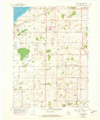
1959 Map of North Cape
USGS Topo · Published 1973About this map
Settled rural landscapes and orderly section roads characterize this 1959 survey of the junction between Waukesha, Milwaukee, and Racine counties. The area is defined by a dense network of local schools and churches that served the small crossroads communities of North Cape and Union Church. A notable concentration of rural education sites includes East Cape Sch, Apple Sch, and Garfield Sch, while industrial activity is represented by a claypit near the center of the sheet. The terrain is marked by the West Branch Root River Canal and the southern reaches of Muskego Lake, reflecting a landscape heavily modified for agriculture. The addition of Aero Estates Landing Field and the Valhalla Landing Strip by the early 1970s illustrates the emerging presence of private aviation in this traditionally agrarian corner of Wisconsin.
Find a feature on this map
48 named features on this map. Tap any name to fly to it.
Don’t see what you’re looking for? This feature index may not catch every label — zoom into the map to look around manually.
Map Details
Editions of this 1959 North Cape Map
3 editions found
Other maps of this area

1891 · Bayview
USGS Topo · 1:62,500

1891 · Muskego
USGS Topo · 1:62,500

1892 · Racine
USGS Topo · 1:62,500

1893 · Silver Lake
USGS Topo · 1:62,500

1901 · Bayview
USGS Topo · 1:62,500

1901 · Muskego
USGS Topo · 1:62,500

1905 · Racine
USGS Topo · 1:62,500

1906 · Silver Lake
USGS Topo · 1:62,500

1954 · Rockford
USGS Topo · 1:250,000

1955 · Rockford
USGS Topo · 1:250,000