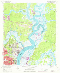
1958 Map of North Charleston
USGS Topo · Published 1973About this map
The Cooper River and its intricate tidal creeks dominate this landscape, illustrating the heavy military and industrial footprint of the mid-20th century. Massive tracts of land are designated as the U S Naval Reservation and the U S Military Reservation, which include the Port Terminal and the Charleston Transportation Corps Depot. This era shows North Charleston expanding into planned residential pockets like Oak Terrace and around the distinctive Park Circle, where schools and churches like St Peters Ch served a growing population.
Find a feature on this map
71 named features on this map. Tap any name to fly to it.
Don’t see what you’re looking for? This feature index may not catch every label — zoom into the map to look around manually.
Map Details
Editions of this 1958 North Charleston Map
4 editions found
Other maps of this area

1919 · Ladson
USGS Topo · 1:21,120

1919 · Johns Island
USGS Topo · 1:21,120

1919 · Summerville
USGS Topo · 1:48,000

1919 · Wando
USGS Topo · 1:21,120

1919 · Cordesville
USGS Topo · 1:48,000

1919 · Melgrove
USGS Topo · 1:21,120

1919 · Charleston
USGS Topo · 1:21,120

1919 · Fort Moultrie
USGS Topo · 1:21,120

1920 · Ravenels
USGS Topo · 1:62,500

1920 · Summerville
USGS Topo · 1:62,500