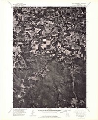
1975 Map of North Freedom NE
USGS Topo · Published 1976About this map
The meandering Baraboo River defines the upper landscape of this orthophotoquad, winding through the fertile agricultural valley of Sauk County. In the mid-1970s, this area reflects a distinct transition between the concentrated residential grids of Baraboo and West Baraboo and the surrounding farmland. The aerial perspective reveals the intricate patterns of strip-cropping and contour plowing that dominate the northern half of the sheet, contrasted against the dense, wooded hills to the south. Near the western edge, North Freedom sits as a compact rail-and-river settlement, its layout clearly visible against the organic curves of the riverbank. This document provides a raw visual record of Wisconsin's rural land-use patterns just before the expansion of modern suburban developments.
Find a feature on this map
4 named features on this map. Tap any name to fly to it.
Don’t see what you’re looking for? This feature index may not catch every label — zoom into the map to look around manually.
Map Details
Editions of this 1975 North Freedom NE Map
2 editions found
Other maps of this area

1895 · Baraboo
USGS Topo · 1:62,500

1901 · Denzer
USGS Topo · 1:62,500

1901 · The Dells
USGS Topo · 1:62,500

1902 · Briggsville
USGS Topo · 1:62,500

1908 · Baraboo
USGS Topo · 1:62,500

1957 · Wisconsin Dells
USGS Topo · 1:62,500

1957 · Madison
USGS Topo · 1:250,000

1958 · Briggsville
USGS Topo · 1:62,500

1958 · North Freedom
USGS Topo · 1:62,500

1959 · Baraboo
USGS Topo · 1:62,500