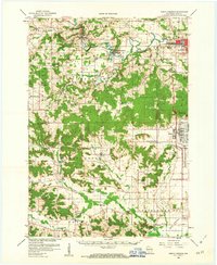
1958 Map of North Freedom
USGS Topo · Published 1963About this map
The Badger Ordnance Works dominates the eastern landscape of Sauk County in this late 1950s record, illustrating the massive industrial footprint of mid-century military production. This sprawling facility stands in sharp contrast to the surrounding rural character of townships like Honey Creek and Freedom. In the village of Denzer, the presence of the Free Thinkers Hall serves as a distinct marker of the region's cultural heritage, while the Baraboo River winds through North Freedom and Rock Springs, mirroring the path of the Chicago and North Western railroad. To the south, the terrain descends toward Sauk Prairie, where small agricultural hubs like Leland, Witwen, and Black Hawk are defined by local institutions such as Our Lady of Loretta Ch and the Hillside Sch. The map also captures the early boundaries of Devils Lake State Park and the specialized grounds of the Mt Ida Convent.
Find a feature on this map
70 named features on this map. Tap any name to fly to it.
Don’t see what you’re looking for? This feature index may not catch every label — zoom into the map to look around manually.
Map Details
Editions of this 1958 North Freedom Map
4 editions found

Other maps of this area

1895 · Baraboo
USGS Topo · 1:62,500

1901 · Denzer
USGS Topo · 1:62,500

1901 · The Dells
USGS Topo · 1:62,500

1902 · Briggsville
USGS Topo · 1:62,500

1905 · Richland Center
USGS Topo · 1:125,000

1907 · Cross Plains
USGS Topo · 1:62,500

1908 · Baraboo
USGS Topo · 1:62,500

1909 · Cross Plains
USGS Topo · 1:62,500

1920 · Blue Mounds
USGS Topo · 1:62,500

1922 · Blue Mounds
USGS Topo · 1:62,500