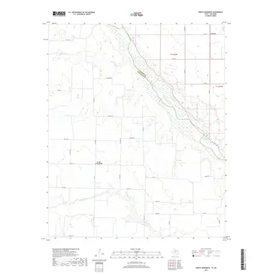
2019 Map of North Groesbeck
USGS Topo · Published 2019About this map
North Groesbeck serves as a central reference point in this rural landscape at the border of Texas and Oklahoma. The area is defined by its complex drainage systems, where N Groesbeck Cr and several smaller tributaries like Papoose Cr and Kid Cr wind through the terrain. The northern boundary of this study is marked by the wide, sandy channel of the Red River, which separates Hardeman County from Jackson County. To the northeast, the settlement of Lincoln sits near the state line, connected to the surrounding ranch and farm lands by a grid of rural roads including Fm 1166 and Ritchie Rd. Local landmarks such as Brooks Springs indicate the location of natural water sources that have long influenced the development and layout of this western territory.
Find a feature on this map
26 named features on this map. Tap any name to fly to it.
Don’t see what you’re looking for? This feature index may not catch every label — zoom into the map to look around manually.
Map Details
Editions of this 2019 North Groesbeck Map
This is the sole edition of this map. No revisions or reprints were ever made.
Other maps of this area

1955 · Lawton
USGS Topo · 1:250,000

1960 · Goodlett
USGS Topo · 1:62,500

1960 · Quanah
USGS Topo · 1:62,500

1961 · Hollis
USGS Topo · 1:62,500

1971 · Duke SW
USGS Topo · 1:24,000

1975 · Hollis SE
USGS Topo · 1:24,000

1975 · Quanah NW
USGS Topo · 1:24,000
1984 · Quanah West
USGS Topo · 1:24,000
1984 · Goodlett
USGS Topo · 1:24,000
1984 · Quanah East
USGS Topo · 1:24,000