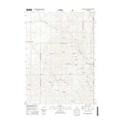
2013 Map of North Heglar Canyon
USGS Topo · Published 2013About this map
Cedar Creek Peak and the southern reaches of the Sublett Range dominate this portion of the Sawtooth National Forest along the border of Cassia and Power counties. The landscape is defined by an intricate network of drainage systems, including North Heglar Canyon and South Heglar Canyon, which channel seasonal water toward the lower valleys. This area reveals a history of land use focused on livestock and small-scale resource extraction, evidenced by the high density of named water sources such as Clint Palmer Spring, Bruce Young Spring, and the curiously named Moonshine Spring. The presence of Mine Dump Spring suggests past prospecting activity amidst the canyons. This 2013 survey provides a clear view of the forest service roads, such as N Heglar Rd, that provide access to high-elevation landmarks like Eagle Point and the various cattle-watering forks.
Find a feature on this map
54 named features on this map. Tap any name to fly to it.
Don’t see what you’re looking for? This feature index may not catch every label — zoom into the map to look around manually.
Map Details
Editions of this 2013 North Heglar Canyon Map
This is the sole edition of this map. No revisions or reprints were ever made.
Other maps of this area

1934 · Rockland
USGS Topo · 1:62,500

1937 · Rockland
USGS Topo · 1:62,500

1954 · Pocatello
USGS Topo · 1:250,000

1958 · Pocatello
USGS Topo · 1:250,000

1958 · Sublett
USGS Topo · 1:62,500

1959 · Yale
USGS Topo · 1:62,500

1971 · Rockland West
USGS Topo · 1:24,000

1973 · Hartley Peak
USGS Topo · 1:24,000

1973 · Sublett Troughs
USGS Topo · 1:24,000
1984 · Malad City
USGS Topo · 1:100,000