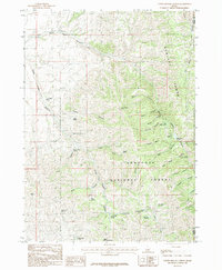
1985 Map of North Heglar Canyon
USGS Topo · Published 1985About this map
The Sublett Range dominates this mid-1980s landscape, where a intricate network of canyons and perennial water sources defines the high country. Part of the Sawtooth National Forest, the terrain is marked by family-named water sources and landmarks that suggest a history of seasonal grazing and high-altitude resource use. The map's high density of named springs, such as Clint Palmer Spring, Bruce Young Spring, and Mine Dump Spring, highlights the critical importance of water management in this arid Idaho environment. These features are situated within a series of deep drainages, including North Heglar Canyon and South Heglar Canyon, which cut through the mountains towards the border of Cassia and Power counties. Geologists and local historians can trace the relationship between physical topography and named points like Cedar Creek Peak and Eagle Point, which served as essential navigational markers for those working the land.
Find a feature on this map
44 named features on this map. Tap any name to fly to it.
Don’t see what you’re looking for? This feature index may not catch every label — zoom into the map to look around manually.
Map Details
Editions of this 1985 North Heglar Canyon Map
This is the sole edition of this map. No revisions or reprints were ever made.
Other maps of this area

1934 · Rockland
USGS Topo · 1:62,500

1937 · Rockland
USGS Topo · 1:62,500

1954 · Pocatello
USGS Topo · 1:250,000

1958 · Pocatello
USGS Topo · 1:250,000

1958 · Sublett
USGS Topo · 1:62,500

1959 · Yale
USGS Topo · 1:62,500

1971 · Rockland West
USGS Topo · 1:24,000

1973 · Hartley Peak
USGS Topo · 1:24,000

1973 · Sublett Troughs
USGS Topo · 1:24,000
1984 · Malad City
USGS Topo · 1:100,000