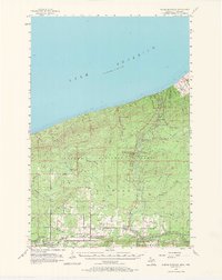
1956 Map of North Ironwood
USGS Topo · Published 1967About this map
Lake Superior dominates the northern horizon of this mid-century survey, where the rugged terrain of the Ottawa National Forest meets the industrial and agricultural corridors of the Western Upper Peninsula. The Black River carves a dramatic path toward the lake, punctuated by a series of significant cascades including Rainbow Falls, Sandstone Falls, and Potawatomi Falls. These features reflect a landscape shaped by water and timber, supporting local recreation at Black River County Park.
Find a feature on this map
47 named features on this map. Tap any name to fly to it.
Don’t see what you’re looking for? This feature index may not catch every label — zoom into the map to look around manually.
Map Details
Editions of this 1956 North Ironwood Map
3 editions found

Other maps of this area

1940 · Upson
USGS Topo · 1:48,000

1943 · Little Girls Point
USGS Topo · 1:24,000

1943 · Upson
USGS Topo · 1:48,000

1943 · Ironwood
USGS Topo · 1:48,000

1943 · Little Girl Point
USGS Topo · 1:48,000

1953 · Ashland
USGS Topo · 1:250,000

1955 · Ironwood
USGS Topo · 1:24,000

1955 · Bessemer
USGS Topo · 1:24,000

1955 · Wakefield
USGS Topo · 1:24,000

1955 · Wakefield
USGS Topo · 1:62,500