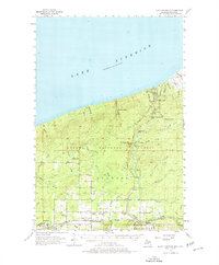
1956 Map of North Ironwood
USGS Topo · Published 1977About this map
Lake Superior dominates the northern horizon of this Upper Peninsula survey, where the rugged terrain of the Ottawa National Forest meets the rocky descent of the Black River. The river's course is punctuated by a series of dramatic landmarks, including Rainbow Falls, Potawatomi Falls, and Great Conglomerate Falls, reflecting the area's transition from high timberland to the lake shore. To the south, the settlement pattern shifts toward small crossroads like Hautala Corner and Auvinen Corner, serving the rural community near North Ironwood. The landscape is tied together by the Duluth South Shore and Atlantic and the Chicago and North Western railroads, which once supported the region's logging and mining industries. Educational and civic hubs like the Roosevelt Sch and the Gogebic County Airport anchor the more developed southern fringe of the quadrangle.
Find a feature on this map
57 named features on this map. Tap any name to fly to it.
Don’t see what you’re looking for? This feature index may not catch every label — zoom into the map to look around manually.
Map Details
Editions of this 1956 North Ironwood Map
3 editions found

Other maps of this area

1940 · Upson
USGS Topo · 1:48,000

1943 · Little Girls Point
USGS Topo · 1:24,000

1943 · Upson
USGS Topo · 1:48,000

1943 · Ironwood
USGS Topo · 1:48,000

1943 · Little Girl Point
USGS Topo · 1:48,000

1953 · Ashland
USGS Topo · 1:250,000

1955 · Ironwood
USGS Topo · 1:24,000

1955 · Bessemer
USGS Topo · 1:24,000

1955 · Wakefield
USGS Topo · 1:24,000

1955 · Wakefield
USGS Topo · 1:62,500