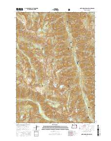
2017 Map of North Minam Meadows
USGS Topo · Published 2017About this map
Wallowa National Forest defines this high-elevation landscape in eastern Oregon, where the headwaters of the Lostine River and N Minam River carve through the Wallowa Mountains. The map detail reflects a wilderness of steep basins and glacial lakes, including Maxwell Lake, John Henry Lake, and Chimney Lake. These water bodies are surrounded by prominent peaks and ridges such as Lookout Mtn, Goat Mtn, and Traverse Ridge. High-altitude grasslands like North Minam Meadows and Lapover Meadows provide important landmarks for those navigating the backcountry. The rugged topography is further illustrated by several passes, notably Sturgil Saddle and Sandy Saddle. Human access is primarily limited to the Upper Lostine Rd corridor, which follows the river through the eastern portion of the quadrangle, illustrating the historic reliance on river valleys for movement through this mountain terrain.
Find a feature on this map
48 named features on this map. Tap any name to fly to it.
Don’t see what you’re looking for? This feature index may not catch every label — zoom into the map to look around manually.
Map Details
Editions of this 2017 North Minam Meadows Map
This is the sole edition of this map. No revisions or reprints were ever made.
Other maps of this area

1906 · Telocaset
USGS Topo · 1:125,000

1954 · Eagle Cap
USGS Topo · 1:62,500

1955 · Grangeville
USGS Topo · 1:250,000

1957 · Enterprise
USGS Topo · 1:62,500

1959 · Grangeville
USGS Topo · 1:250,000

1965 · China Cap
USGS Topo · 1:24,000

1965 · Fox Point
USGS Topo · 1:24,000
1966 · Jim White Ridge
USGS Topo · 1:24,000

1986 · Enterprise
USGS Topo · 1:100,000

1990 · Lostine
USGS Topo · 1:24,000