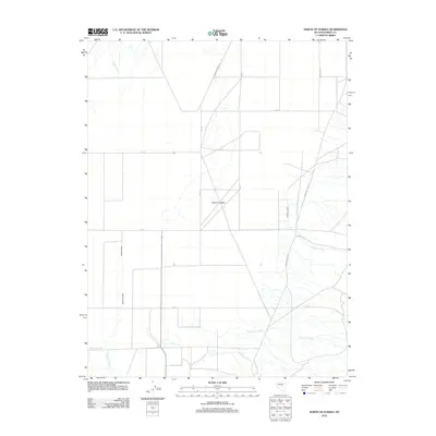
2012 Map of North of Eureka
USGS Topo · Published 2012About this map
Diamond Valley serves as the central focal point of this Nevada survey, characterized by an orderly grid of roads that intersect the arid landscape. The northern reaches of the valley are defined by the Diamond Foothill and the prominent Black Pt, where the terrain begins its ascent away from the basin floor. This area shows a transition from the agricultural or residential potential of the valley floor—marked by named thoroughfares like Java 101 and Keg St—to the natural drainages that channel seasonal water from the heights. Key hydrological features such as Pedrioli Creek, Minoletti Creek, and Cottonwood Creek flow from the foothills toward the valley, while Slough Creek and Simpson Creek anchor the western portion of the quadrangle. The map captures a moment in the early 21st century when the systematic organization of the high desert was well-established, linked by routes like the Eureka-Thompsons road.
Find a feature on this map
18 named features on this map. Tap any name to fly to it.
Don’t see what you’re looking for? This feature index may not catch every label — zoom into the map to look around manually.
Map Details
Editions of this 2012 North of Eureka Map
This is the sole edition of this map. No revisions or reprints were ever made.
Other maps of this area

1926 · Roberts Mountains
USGS Topo · 1:250,000

1929 · Roberts Mountains
USGS Topo · 1:250,000

1949 · Garden Valley
USGS Topo · 1:62,500

1951 · Garden Valley
USGS Topo · 1:62,500

1953 · Eureka
USGS Topo · 1:62,500

1955 · Millett
USGS Topo · 1:250,000

1956 · Whistler Mtn
USGS Topo · 1:62,500

1956 · Ely
USGS Topo · 1:250,000

1957 · Diamond Springs
USGS Topo · 1:62,500

1959 · Ely
USGS Topo · 1:250,000