
1973 Map of North Of Fiftymile Bend
USGS Topo · Published 1990About this map
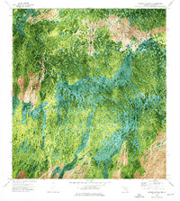
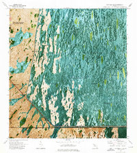
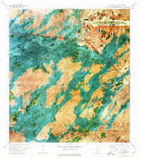
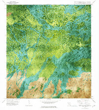
Threemile Island sits within a mosaic of cypress strands and wet prairies in this remote section of Collier County, documented through a 1971 aerial orthophotomap and verified in the early 1970s. The landscape is defined by the absence of permanent human settlement, instead featuring natural landmarks and the Corn Dance Trail winding through the southern reaches of the quadrangle. This survey illustrates a specific moment in the Everglades' environmental history before significant drainage or modernization altered the subtle flow of surface water. The orthophoto format provides an unique look at the vegetation patterns and hammock distributions that traditional line maps often simplify, preserving the complex texture of the Florida interior during the mid-twentieth century.
Find a feature on this map
5 named features on this map. Tap any name to fly to it.
Don’t see what you’re looking for? This feature index may not catch every label — zoom into the map to look around manually.
Map Details
Editions of this 1973 North Of Fiftymile Bend Map
2 editions found
Other maps of this area

1956 · Miami
USGS Topo · 1:250,000

1956 · West Palm Beach
USGS Topo · 1:250,000

1957 · West Palm Beach
USGS Topo · 1:250,000

1958 · West Palm Beach
USGS Topo · 1:250,000

1958 · Miami
USGS Topo · 1:250,000
1972 · Monroe Station NE
USGS Topo · 1:24,000
1973 · Fortymile Bend
USGS Topo · 1:24,000
1973 · Fiftymile Bend
USGS Topo · 1:24,000
1973 · North Of Fiftymile Bend
USGS Topo · 1:24,000

1973 · Monroe Station
USGS Topo · 1:24,000