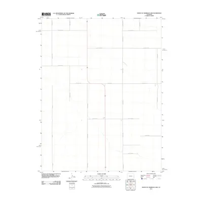
2010 Map of North of Sheridan Lake
USGS Topo · Published 2010About this map
The high plains of Cheyenne County are defined here by a precise grid of rural thoroughfares, reflecting the systematic land division of eastern Colorado. This 2010 survey shows a landscape dominated by agriculture and livestock management, where mobility is anchored to a network that includes County Road A at the northern boundary and County Road U to the south. The absence of concentrated settlements highlights the vast, open nature of this region, while the inclusion of the latitudinal County Road AA and County Road Y demonstrates the infrastructure required to service isolated farmsteads and ranching operations. The terrain is notably sparse, with ephemeral watercourses crossing the grid at irregular intervals, primarily between County Road W and County Road V.
Find a feature on this map
17 named features on this map. Tap any name to fly to it.
Don’t see what you’re looking for? This feature index may not catch every label — zoom into the map to look around manually.
Map Details
Editions of this 2010 North of Sheridan Lake Map
This is the sole edition of this map. No revisions or reprints were ever made.
Other maps of this area

1890 · Granada
USGS Topo · 1:125,000

1892 · Cheyenne Wells
USGS Topo · 1:125,000

1892 · Granada
USGS Topo · 1:125,000

1894 · Cheyenne Wells
USGS Topo · 1:125,000

1894 · Granada
USGS Topo · 1:125,000

1954 · Lamar
USGS Topo · 1:250,000

1958 · Lamar
USGS Topo · 1:250,000

1968 · Stuart
USGS Topo · 1:24,000

1968 · Sheridan Lake
USGS Topo · 1:24,000
1968 · Brandon
USGS Topo · 1:24,000