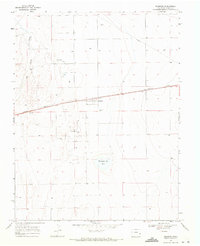
1968 Map of Brandon
USGS Topo · Published 1971About this map
Brandon sits at the intersection of industry and the high plains, serving as a hub for the surrounding Brandon Oil Field. This 1960s landscape is defined by the straight line of the Missouri Pacific railroad, which parallels the highway and connects the small settlements of the region. To the west, the ephemeral path of Big Sandy Creek winds through the terrain, while the Chivington Res No 4 reservoir provides a vital water source for this arid environment. The map records a quiet agricultural and industrial transition, where a Pipeline and scattered sites like a Gravel Pit indicate the local extraction economy. Genealogists and local historians will find value in the location of the Plainview Cem and the small residential pocket of Chivington on the western edge of the survey.
Find a feature on this map
12 named features on this map. Tap any name to fly to it.
Don’t see what you’re looking for? This feature index may not catch every label — zoom into the map to look around manually.
Map Details
Editions of this 1968 Brandon Map
This is the sole edition of this map. No revisions or reprints were ever made.
Other maps of this area

1890 · Granada
USGS Topo · 1:125,000

1891 · Kit Carson
USGS Topo · 1:125,000

1892 · Lamar
USGS Topo · 1:125,000

1892 · Cheyenne Wells
USGS Topo · 1:125,000

1892 · Granada
USGS Topo · 1:125,000

1893 · Kit Carson
USGS Topo · 1:125,000

1894 · Cheyenne Wells
USGS Topo · 1:125,000

1894 · Granada
USGS Topo · 1:125,000

1954 · Lamar
USGS Topo · 1:250,000

1958 · Lamar
USGS Topo · 1:250,000