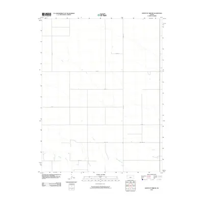
2010 Map of North of Tribune
USGS Topo · Published 2010About this map
White Woman Creek winds through this expanse of high plains landscape north of the county seat, defining the few variations in the otherwise strict township-and-range grid. This 2010 USGS survey shows a region deeply tied to the rural section-line road system, where corridors like State Hwy 27 and Horace Rd provide the primary connectivity across Greeley County. The map captures the quiet transition of land use along the creek bed, surrounded by the geometric precision of agricultural parcels bounded by local routes such as Four Mile Rd and Co Rd N. It serves as a clear record of the modern rural infrastructure in Tribune Township, where the vastness of the prairie is organized by a network of numbered county roads like Co Rd 11 and Co Rd 15.
Find a feature on this map
13 named features on this map. Tap any name to fly to it.
Don’t see what you’re looking for? This feature index may not catch every label — zoom into the map to look around manually.
Map Details
Editions of this 2010 North of Tribune Map
This is the sole edition of this map. No revisions or reprints were ever made.
Other maps of this area

1955 · Scott City
USGS Topo · 1:250,000

1958 · Scott City
USGS Topo · 1:250,000

1968 · Sharon Springs 3 NE
USGS Topo · 1:24,000

1968 · Sharon Springs 4 NW
USGS Topo · 1:24,000

1968 · Sharon Springs 3 NW
USGS Topo · 1:24,000

1970 · Sharon Springs 3 SE
USGS Topo · 1:24,000

1970 · Sharon Springs 4 SW
USGS Topo · 1:24,000
1970 · Sharon Springs 3 SW
USGS Topo · 1:24,000

1970 · Selkirk NW
USGS Topo · 1:24,000
1970 · Tribune NW
USGS Topo · 1:24,000