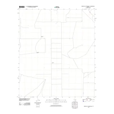
2010 Map of North of Tucker Hill
USGS Topo · Published 2010About this map
Blue Ridge Farm and several critical water points anchor this high-plains landscape in Pecos County during the early 21st century. The map depicts a sparse, functional grid of roads and landmarks essential for agriculture and ranching in a territory defined by its wide horizons. Isolated infrastructure like the McCarmack Windmill and the East Sanders Windmill serve as primary navigational markers and survival resources in this section of the Texas backcountry. These features, along with routes like Co Rd 111, Co Rd 108, and Mendel Rd, represent the specialized settlement pattern of a region where water management and long-distance travel are central to daily life. The geometric precision of the property and road lines reveals the late-modern organization of the West Texas range.
Find a feature on this map
6 named features on this map. Tap any name to fly to it.
Don’t see what you’re looking for? This feature index may not catch every label — zoom into the map to look around manually.
Map Details
Editions of this 2010 North of Tucker Hill Map
This is the sole edition of this map. No revisions or reprints were ever made.
Other maps of this area

1929 · Hovey
USGS Topo · 1:125,000

1931 · Barstow
USGS Topo · 1:125,000

1954 · Pecos
USGS Topo · 1:250,000

1954 · Fort Stockton
USGS Topo · 1:250,000

1957 · Pecos
USGS Topo · 1:250,000

1958 · Fort Stockton
USGS Topo · 1:250,000

1970 · Tucker Hill
USGS Topo · 1:24,000
1970 · Barstow 3 SW
USGS Topo · 1:24,000

1970 · Belding NW
USGS Topo · 1:24,000
1970 · Barstow 3 SE
USGS Topo · 1:24,000