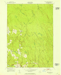
1943 Map of North Osceola
USGS Topo · Published 1953About this map
The Salmon River and its numerous tributaries dominate this mid-century view of the Tug Hill region. The settlement pattern is sparse, concentrated primarily around North Osceola and the town of Osceola in the southern portion of the quadrangle. Local infrastructure is evidenced by legacy education sites like School No 7 and School No 2, while the presence of the New Campbellwood Wye and Old Campbellwood Wye suggests the area's historical connection to logging or specialized rail transport.
Find a feature on this map
38 named features on this map. Tap any name to fly to it.
Don’t see what you’re looking for? This feature index may not catch every label — zoom into the map to look around manually.
Map Details
Editions of this 1943 North Osceola Map
Other maps of this area

1903 · Orwell
USGS Topo · 1:62,500

1905 · Orwell
USGS Topo · 1:62,500

1905 · Taberg
USGS Topo · 1:62,500

1906 · Highmarket
USGS Topo · 1:62,500

1906 · Kasoag
USGS Topo · 1:62,500

1942 · Redfield
USGS Topo · 1:24,000

1943 · Redfield
USGS Topo · 1:31,680

1943 · Westdale
USGS Topo · 1:31,680

1943 · East Florence
USGS Topo · 1:31,680
1943 · Worth Center
USGS Topo · 1:31,680