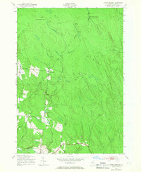
1943 Map of North Osceola
USGS Topo · Published 1966About this map
The Salmon River watershed dominates this 1940s landscape in the town of Osceola, Lewis County, during an era defined by timber and transit. The map reveals the intricate drainage patterns of the Tug Hill region, centered on the confluence of the West Fork Salmon River and the East Fork Salmon River. Distinctive transportation history is etched into the terrain at New Campbellwood Wye and Old Campbellwood Wye, indicating the specialized rail configurations used for logging or maneuvering in this densely wooded area. Settlement is concentrated along the river valley and Redfield Road, where rural life is anchored by School No 7 and School No 8. Outside these small clearings, the map shows a network of named waterways like Pickens Brook and Fall Brook carving through the plateau toward the river, while the Old Martinsburg Road and various trails provide the only passage through the high ground of Wards Hill.
Find a feature on this map
51 named features on this map. Tap any name to fly to it.
Don’t see what you’re looking for? This feature index may not catch every label — zoom into the map to look around manually.
Map Details
Editions of this 1943 North Osceola Map
Other maps of this area

1903 · Orwell
USGS Topo · 1:62,500

1905 · Orwell
USGS Topo · 1:62,500

1905 · Taberg
USGS Topo · 1:62,500

1906 · Highmarket
USGS Topo · 1:62,500

1906 · Kasoag
USGS Topo · 1:62,500

1942 · Redfield
USGS Topo · 1:24,000

1943 · Redfield
USGS Topo · 1:31,680

1943 · Westdale
USGS Topo · 1:31,680

1943 · East Florence
USGS Topo · 1:31,680
1943 · Worth Center
USGS Topo · 1:31,680