
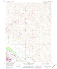
1970 Map of North Platte East
USGS Topo · Published 1973About this map
The confluence of river commerce and transportation infrastructure defines this portion of Lincoln County just east of North Platte. The North Platte River winds through the southern landscape, paralleled by the vital Union Pacific railroad corridor. This area serves as a primary transit and service hub for the region, anchored by the expansive Lee Bird Field and municipal utilities like the Sewage Disposal Ponds.
Find a feature on this map
27 named features on this map. Tap any name to fly to it.
Don’t see what you’re looking for? This feature index may not catch every label — zoom into the map to look around manually.
Map Details
Editions of this 1970 North Platte East Map
2 editions found
Other maps of this area

1899 · North Platte
USGS Topo · 1:125,000

1902 · North Platte
USGS Topo · 1:125,000

1954 · North Platte
USGS Topo · 1:250,000

1956 · North Platte
USGS Topo · 1:250,000

1957 · North Platte
USGS Topo · 1:250,000

1967 · North Platte
USGS Topo · 1:250,000

1970 · North Platte West
USGS Topo · 1:24,000
1970 · Maxwell
USGS Topo · 1:24,000
1970 · Maxwell SW
USGS Topo · 1:24,000
1970 · Lake Maloney
USGS Topo · 1:24,000