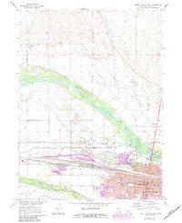
1970 Map of North Platte West
USGS Topo · Published 1983About this map
The confluence of the North Platte River and the South Platte River anchors this study of Western Nebraska's central hub during the early 1970s. The city of North Platte is shown in considerable detail, concentrated south of the massive Union Pacific railyards and extending toward the Lincoln County Courthouse. Local history is preserved in the location of civic landmarks like St Patricks High Sch, the North Platte Cem, and Buffalo Bill Ranch State Park. The landscape outside the city center is defined by a network of water management features, including several labeled Flume segments and the Canal, which crisscross the river valley. The map also captures mid-century social infrastructure, from the Drive-in Theater and North Platte Country Club to various residential Trailer Park clusters that marked the city's expanding footprint.
Find a feature on this map
48 named features on this map. Tap any name to fly to it.
Don’t see what you’re looking for? This feature index may not catch every label — zoom into the map to look around manually.
Map Details
Editions of this 1970 North Platte West Map
2 editions found
Other maps of this area

1899 · North Platte
USGS Topo · 1:125,000

1902 · North Platte
USGS Topo · 1:125,000

1954 · North Platte
USGS Topo · 1:250,000

1956 · North Platte
USGS Topo · 1:250,000

1957 · North Platte
USGS Topo · 1:250,000

1967 · North Platte
USGS Topo · 1:250,000

1970 · North Platte East
USGS Topo · 1:24,000

1970 · North Platte West
USGS Topo · 1:24,000
1970 · North Platte SW
USGS Topo · 1:24,000
1970 · Hershey East
USGS Topo · 1:24,000
Featured Places
- North Platte, NE
- Green Acres Trailer Court, NE
- Mobile Manor, North Platte
- Village Square, North Platte
- Key Estates, North Platte