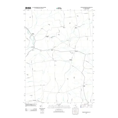
2013 Map of North Western
USGS Topo · Published 2013About this map
North Western and Frenchville anchor the northwestern reaches of this Oneida County landscape, situated along the path of the historic Black River Canal. The terrain is defined by a series of prominent rises including Maple Mountain, Carmichael Hill, and Boody Hill, separated by a dense network of watercourses like Tannery Brook and Gifford Cr. The map reveals a deeply rooted rural community, evidenced by the numerous family and community burial grounds such as Steuben Cem, Nisbet Cem, and Ward Cem that dot the countryside. This 2013 survey shows the evolution of the area from its 19th-century canal-era roots to contemporary land uses, including the Camroden Golf Course and Belle Maison Farms in the south. The transition from the rugged highlands of Buck Hill to the more developed settlements like East Floyd illustrates the diverse topography of the Tug Hill region's southern edge.
Find a feature on this map
91 named features on this map. Tap any name to fly to it.
Don’t see what you’re looking for? This feature index may not catch every label — zoom into the map to look around manually.
Map Details
Editions of this 2013 North Western Map
This is the sole edition of this map. No revisions or reprints were ever made.
Other maps of this area

1895 · Oriskany
USGS Topo · 1:62,500

1897 · Remsen
USGS Topo · 1:62,500

1898 · Utica
USGS Topo · 1:62,500

1898 · Oriskany
USGS Topo · 1:62,500

1900 · Utica
USGS Topo · 1:62,500

1900 · Remsen
USGS Topo · 1:62,500

1904 · Boonville
USGS Topo · 1:62,500
1945 · South Trenton
USGS Topo · 1:31,680

1945 · Boonville
USGS Topo · 1:24,000

1945 · Forestport
USGS Topo · 1:24,000