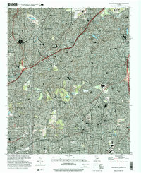
1997 Map of Northeast Atlanta
USGS Topo · Published 1999About this map
Emory University and the wooded residential enclaves of Druid Hills anchor the heart of this late-twentieth-century landscape. The map shows a densely developed corridor where the Fulton Co De Kalb Co line separates the metropolitan reach of Atlanta from the historic municipalities of Decatur and Avondale Estates. Educational and institutional presence is particularly heavy, featuring Agnes Scott College, the Columbia Seminary, and Mercer University of Atlanta. Transportation networks define the area's growth, from the industrial path of the Georgia Railroad to the sprawling Northeast Expressway. Neighborhoods like Inman Park and Little Five Points showcase the established urban fabric, while the northern reaches are dominated by the De Kalb Peachtree Airport and major retail hubs like Lenox Square Mall. Waterways including South Fork Peachtree Creek wind through the hills, providing natural breaks between these storied communities.
Find a feature on this map
76 named features on this map. Tap any name to fly to it.
Don’t see what you’re looking for? This feature index may not catch every label — zoom into the map to look around manually.
Map Details
Editions of this 1997 Northeast Atlanta Map
This is the sole edition of this map. No revisions or reprints were ever made.
Other maps of this area

1888 · Atlanta
USGS Topo · 1:125,000

1890 · Atlanta
USGS Topo · 1:125,000

1892 · Atlanta
USGS Topo · 1:125,000

1895 · Atlanta
USGS Topo · 1:125,000

1953 · Atlanta
USGS Topo · 1:250,000

1954 · Conley
USGS Topo · 1:24,000

1954 · Chamblee
USGS Topo · 1:24,000

1954 · Decatur
USGS Topo · 1:24,000

1954 · Bolton
USGS Topo · 1:24,000

1954 · East Point
USGS Topo · 1:24,000