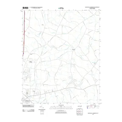
2010 Map of Northeast Lumberton
USGS Topo · Published 2010About this map
Lumberton serves as the focal point of this region, with the suburban extension of Elizabeth Heights branching out to the northeast. The landscape is defined by an intricate network of wetlands and drainage systems, most notably the wide reach of Tenmile Swamp and White Oak Swamp, which dictate the placement of rural homesteads and agricultural roads. These corridors are punctuated by small, family-associated burial grounds like Thomas Cemetery and Kinlaw Cemetery, which offer valuable data points for local genealogists.
Find a feature on this map
81 named features on this map. Tap any name to fly to it.
Don’t see what you’re looking for? This feature index may not catch every label — zoom into the map to look around manually.
Map Details
Editions of this 2010 Northeast Lumberton Map
This is the sole edition of this map. No revisions or reprints were ever made.
Other maps of this area

1953 · Florence
USGS Topo · 1:250,000

1954 · Florence
USGS Topo · 1:250,000

1957 · Bladenboro
USGS Topo · 1:62,500

1959 · Saint Pauls
USGS Topo · 1:62,500

1972 · Northwest Lumberton
USGS Topo · 1:24,000

1972 · Southwest Lumberton
USGS Topo · 1:24,000

1972 · Rennert
USGS Topo · 1:24,000
1976 · Southwest Lumberton
USGS Topo · 1:24,000

1976 · Rennert
USGS Topo · 1:24,000
1976 · Northwest Lumberton
USGS Topo · 1:24,000