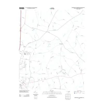
2013 Map of Northeast Lumberton
USGS Topo · Published 2013About this map
Howellsville and the surrounding agricultural landscapes of Robeson County are defined by a complex network of wetlands and small drainages that feed into the larger Lumbee River basin. This survey documents the rural character of the region, where family names and local history are etched into the road network, including Rozier Siding Rd and Smith Mill Rd. The terrain is dominated by the extensive Tenmile Swamp and Jackson Swamp, which dictate the placement of early settlements like Powers and Barker Ten Mile. To the east, the landscape transitions toward White Oak Swamp and White Oak Lake, illustrating the hydrologic patterns that have influenced land use and transportation in this part of North Carolina for generations. The map provides a clear record of these watercourses, from Cowpen Branch in the northwest to Wildcat Br in the northeast, alongside the evolving road system of the early 21st century.
Find a feature on this map
137 named features on this map. Tap any name to fly to it.
Don’t see what you’re looking for? This feature index may not catch every label — zoom into the map to look around manually.
Map Details
Editions of this 2013 Northeast Lumberton Map
This is the sole edition of this map. No revisions or reprints were ever made.
Other maps of this area

1953 · Florence
USGS Topo · 1:250,000

1954 · Florence
USGS Topo · 1:250,000

1957 · Bladenboro
USGS Topo · 1:62,500

1959 · Saint Pauls
USGS Topo · 1:62,500

1972 · Northwest Lumberton
USGS Topo · 1:24,000

1972 · Southwest Lumberton
USGS Topo · 1:24,000

1972 · Rennert
USGS Topo · 1:24,000
1976 · Southwest Lumberton
USGS Topo · 1:24,000
1976 · Rennert
USGS Topo · 1:24,000
1976 · Northwest Lumberton
USGS Topo · 1:24,000