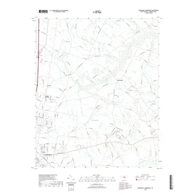
2019 Map of Northeast Lumberton
USGS Topo · Published 2019About this map
Lumberton and the surrounding coastal plain of Robeson County are characterized by an intricate network of wetlands and agricultural tracts. The northeast quadrant of the city transitions from the residential areas of Elizabeth Heights into a landscape dominated by distinct topographical depressions and drainages, such as Cypress Bay, Big Bay, and the expansive Tenmile Swamp. These "bays," characteristic of the Carolina coast, influence the local road patterns and settlement locations, including the community of Howellsville and the high ground near Cricket Hollow.
Find a feature on this map
138 named features on this map. Tap any name to fly to it.
Don’t see what you’re looking for? This feature index may not catch every label — zoom into the map to look around manually.
Map Details
Editions of this 2019 Northeast Lumberton Map
This is the sole edition of this map. No revisions or reprints were ever made.
Other maps of this area

1953 · Florence
USGS Topo · 1:250,000

1954 · Florence
USGS Topo · 1:250,000

1957 · Bladenboro
USGS Topo · 1:62,500

1959 · Saint Pauls
USGS Topo · 1:62,500

1972 · Northwest Lumberton
USGS Topo · 1:24,000

1972 · Southwest Lumberton
USGS Topo · 1:24,000

1972 · Rennert
USGS Topo · 1:24,000
1976 · Southwest Lumberton
USGS Topo · 1:24,000
1976 · Rennert
USGS Topo · 1:24,000
1976 · Northwest Lumberton
USGS Topo · 1:24,000