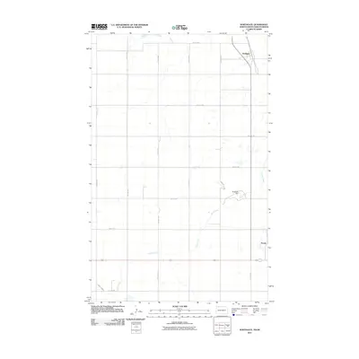
2011 Map of Northgate
USGS Topo · Published 2011About this map
Northgate sits at the international boundary between North Dakota and Saskatchewan, serving as a primary point of transit in this northern prairie landscape. The area is defined by a grid of rural routes, including 75th Ave NW and 109th St NW, which segment the agricultural terrain near the Canadian border. Hydrological features like Stony Creek wind through the region, eventually pooling at the Northgate Dam just south of the border crossing. The small settlement of Perella appears further south along the eastern edge of the quadrangle. This 2011 survey by the U.S. Geological Survey illustrates the intersection of international infrastructure and the persistent drainage patterns of the northern plains, where local transport depends on a network of numbered avenues and streets.
Find a feature on this map
20 named features on this map. Tap any name to fly to it.
Don’t see what you’re looking for? This feature index may not catch every label — zoom into the map to look around manually.
Map Details
Editions of this 2011 Northgate Map
This is the sole edition of this map. No revisions or reprints were ever made.
Other maps of this area

1947 · Bowbells NW
USGS Topo · 1:24,000

1947 · Flaxton
USGS Topo · 1:24,000

1947 · Bowbells
USGS Topo · 1:24,000

1948 · Flaxton
USGS Topo · 1:24,000

1948 · Coteau
USGS Topo · 1:24,000

1948 · Woburn
USGS Topo · 1:24,000

1949 · Bowbells
USGS Topo · 1:24,000

1949 · Bowbells NW
USGS Topo · 1:24,000
1949 · Northgate
USGS Topo · 1:24,000

1950 · Bowbells
USGS Topo · 1:62,500