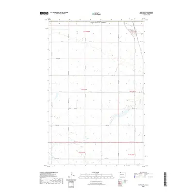
2020 Map of Northgate
USGS Topo · Published 2020About this map
The border community of Northgate sits at the northern edge of this survey, directly along the Canada United States of America international boundary. This high-plains landscape in Burke County is defined by a rigorous section-line road grid, including Co Hwy 2 and numerous numbered streets such as 102nd St NW. The terrain is characterized by prairie potholes and the meandering course of Stony Cr, which flows through the eastern and southern portions of the quadrangle. A significant local landmark for genealogists is the Ebenezer Lutheran Cem, located along 104th St NW, serving as a silent witness to the area's agricultural heritage and Scandinavian settlement patterns.
Find a feature on this map
22 named features on this map. Tap any name to fly to it.
Don’t see what you’re looking for? This feature index may not catch every label — zoom into the map to look around manually.
Map Details
Editions of this 2020 Northgate Map
This is the sole edition of this map. No revisions or reprints were ever made.
Other maps of this area

1947 · Bowbells NW
USGS Topo · 1:24,000

1947 · Flaxton
USGS Topo · 1:24,000

1947 · Bowbells
USGS Topo · 1:24,000

1948 · Flaxton
USGS Topo · 1:24,000

1948 · Coteau
USGS Topo · 1:24,000

1948 · Woburn
USGS Topo · 1:24,000

1949 · Bowbells
USGS Topo · 1:24,000

1949 · Bowbells NW
USGS Topo · 1:24,000
1949 · Northgate
USGS Topo · 1:24,000

1950 · Bowbells
USGS Topo · 1:62,500