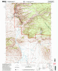
2000 Map of Northgate
USGS Topo · Published 2004About this map
North Platte River waters carve a complex path through this high-altitude landscape where the Medicine Bow National Forest and Routt National Forest meet at the Colorado-Wyoming border. The terrain is defined by prominent peaks like Independence Mountain and Sentinel Mountain, with the Platte River Wilderness protecting the river's northern corridor. This area was an active mining and ranching hub, evidenced by the Camp Creek Mine, Fluorspar Mine, and Penbar Mine scattered across the slopes. A sophisticated irrigation network of gravity-fed channels, including Capron Ditch, Newport Ditch, and Cumberland Ditch, diverts water from the Canadian River and Pinkham Creek to support local agricultural operations like the Ginger Quill Ranch. The small settlement of Northgate serves as a critical junction for both the railroad and local road networks near the foot of Watson Mountain.
Find a feature on this map
36 named features on this map. Tap any name to fly to it.
Don’t see what you’re looking for? This feature index may not catch every label — zoom into the map to look around manually.
Map Details
Editions of this 2000 Northgate Map
This is the sole edition of this map. No revisions or reprints were ever made.
Other maps of this area

1906 · Medicine Bow
USGS Topo · 1:125,000

1908 · Medicine Bow
USGS Topo · 1:125,000

1950 · Northgate
USGS Topo · 1:24,000

1950 · Kings Canyon
USGS Topo · 1:24,000

1952 · Northgate
USGS Topo · 1:24,000

1952 · Kings Canyon
USGS Topo · 1:24,000

1954 · Rawlins
USGS Topo · 1:250,000

1954 · Craig
USGS Topo · 1:250,000

1955 · Independence Mountain
USGS Topo · 1:24,000

1955 · Lake John
USGS Topo · 1:24,000