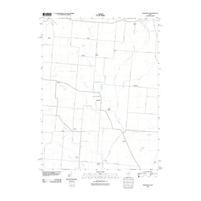
2010 Map of Northville
USGS Topo · Published 2010About this map
The Mad River valley in Champaign County is defined by a dense network of family and community burial grounds, reflecting the long-established agricultural heritage of this central Ohio landscape. Small settlements like Northville, Lippincott, and Eris anchor a grid of rural roads, including the Woodville Pike and Upper Valley Pike. The terrain is shaped by numerous watercourses such as Muddy Creek, Spring Run, and Anderson Creek, which feed into the primary river system or local landmarks like Sayres Ponds. For genealogists, the map is remarkably dense with specific sites for local history research, featuring over a dozen named cemeteries including Muddy Run Cemetery, Wesley Chapel Cemetery, and the Idle and Stevens Cemetery. Aviation history is represented at the southern edge by Grimes Field, while the inclusion of Camp Shawnee and Macochee Ditch further illustrates the varied land use between traditional farming and community recreation.
Find a feature on this map
54 named features on this map. Tap any name to fly to it.
Don’t see what you’re looking for? This feature index may not catch every label — zoom into the map to look around manually.
Map Details
Editions of this 2010 Northville Map
This is the sole edition of this map. No revisions or reprints were ever made.
Other maps of this area

1913 · Bellefontaine
USGS Topo · 1:48,000

1913 · East Liberty
USGS Topo · 1:62,500

1914 · St. Paris
USGS Topo · 1:62,500

1914 · Mechanicsburg
USGS Topo · 1:62,500

1915 · Bellefontaine
USGS Topo · 1:62,500

1915 · East Liberty
USGS Topo · 1:62,500

1916 · Mechanicsburg
USGS Topo · 1:62,500

1916 · St. Paris
USGS Topo · 1:62,500

1944 · East Liberty
USGS Topo · 1:62,500

1944 · Mechanicsburg
USGS Topo · 1:62,500