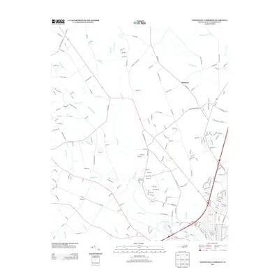
2013 Map of Northwest Lumberton
USGS Topo · Published 2013About this map
Raft Swamp and its numerous tributaries dominate the landscape northwest of Lumberton, creating a complex drainage network that includes Richland Swamp, Burnt Swamp, and Holy Swamp. This 2013 survey illustrates the transition from rural Robeson County to the expanding urban edge, where traditional agricultural settlements like Saddletree and Lowe are increasingly connected by modern developments. The southern portion of the map follows the winding course of the Lumber River, where smaller branches like Fivemile Br and Meadow Br feed into the main channel. Family-named roads such as McQueen Rd, Buies Mill Rd, and Snipes Rd offer researchers a look at local land ownership patterns and historic rural routes. The presence of Circle T Lake and Little Tenmile Swamp further emphasizes the wetland character of this coastal plain terrain.
Find a feature on this map
196 named features on this map. Tap any name to fly to it.
Don’t see what you’re looking for? This feature index may not catch every label — zoom into the map to look around manually.
Map Details
Editions of this 2013 Northwest Lumberton Map
This is the sole edition of this map. No revisions or reprints were ever made.
Other maps of this area

1953 · Florence
USGS Topo · 1:250,000

1954 · Florence
USGS Topo · 1:250,000

1957 · Bladenboro
USGS Topo · 1:62,500

1959 · Saint Pauls
USGS Topo · 1:62,500

1972 · Northwest Lumberton
USGS Topo · 1:24,000

1972 · Southwest Lumberton
USGS Topo · 1:24,000

1972 · Rennert
USGS Topo · 1:24,000

1972 · Pembroke
USGS Topo · 1:24,000
1972 · Mc Donald
USGS Topo · 1:24,000
1974 · Red Springs
USGS Topo · 1:24,000