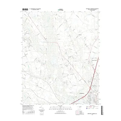
2016 Map of Northwest Lumberton
USGS Topo · Published 2016About this map
The Lumber River and its dense network of tributaries, including Raft Swamp and Bear Swamp, define the low-lying terrain northwest of Lumberton. This 2016 survey documents a landscape where traditional agricultural roads intersect with modern residential growth, particularly in the unincorporated communities of Saddletree and Barker Ten Mile. The map is a valuable resource for genealogical research, identifying numerous family-named landmarks and resting places such as Lowry Cem, Oxendine Cem, and McNeill Cem.
Find a feature on this map
178 named features on this map. Tap any name to fly to it.
Don’t see what you’re looking for? This feature index may not catch every label — zoom into the map to look around manually.
Map Details
Editions of this 2016 Northwest Lumberton Map
This is the sole edition of this map. No revisions or reprints were ever made.
Other maps of this area

1953 · Florence
USGS Topo · 1:250,000

1954 · Florence
USGS Topo · 1:250,000

1957 · Bladenboro
USGS Topo · 1:62,500

1959 · Saint Pauls
USGS Topo · 1:62,500

1972 · Northwest Lumberton
USGS Topo · 1:24,000

1972 · Southwest Lumberton
USGS Topo · 1:24,000

1972 · Rennert
USGS Topo · 1:24,000

1972 · Pembroke
USGS Topo · 1:24,000
1972 · Mc Donald
USGS Topo · 1:24,000
1974 · Red Springs
USGS Topo · 1:24,000