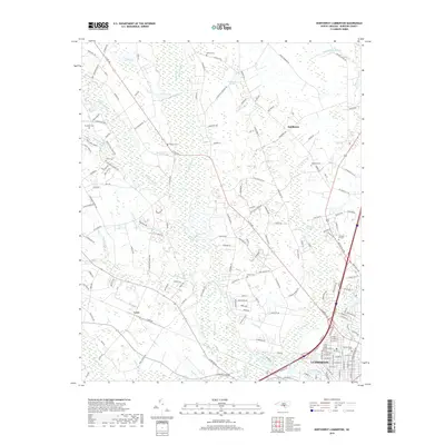
2019 Map of Northwest Lumberton
USGS Topo · Published 2019About this map
Lumberton and its northern outskirts are defined by an intricate network of wetlands and river systems that have shaped Robeson County’s development. The Lumber River flows along the southern edge, while the interior is dominated by the sprawling Raft Swamp and its various tributaries like Richland Swamp and Mill Br. These water bodies are interspersed with established settlements such as Saddletree and Lowe, alongside residential pockets like Meadowbrook. Family history is deeply rooted in the landscape, evidenced by numerous burial grounds including Lowry Cem, Maynor Cem, and Oxendine Cem that dot the rural stretches between farms and woodlots. Significant landmarks like the Gardens of Faith memorial park and Circle T Lake provide community anchors within this coastal plain environment where agriculture and traditional settlements persist alongside the expanding urban footprint of the county seat.
Find a feature on this map
175 named features on this map. Tap any name to fly to it.
Don’t see what you’re looking for? This feature index may not catch every label — zoom into the map to look around manually.
Map Details
Editions of this 2019 Northwest Lumberton Map
This is the sole edition of this map. No revisions or reprints were ever made.
Other maps of this area

1953 · Florence
USGS Topo · 1:250,000

1954 · Florence
USGS Topo · 1:250,000

1957 · Bladenboro
USGS Topo · 1:62,500

1959 · Saint Pauls
USGS Topo · 1:62,500

1972 · Northwest Lumberton
USGS Topo · 1:24,000

1972 · Southwest Lumberton
USGS Topo · 1:24,000

1972 · Rennert
USGS Topo · 1:24,000

1972 · Pembroke
USGS Topo · 1:24,000
1972 · Mc Donald
USGS Topo · 1:24,000
1974 · Red Springs
USGS Topo · 1:24,000