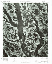
1976 Map of Northwest Lumberton
USGS Topo · Published 1978About this map
Lumberton sits at the southern edge of this mid-1970s orthophotograph, where the city’s residential streets begin to yield to the expansive agricultural and wooded landscape of Robeson County. The image, captured in January 1976, reveals a patchwork of cleared fields and dense forest typical of the North Carolina coastal plain during this era. Dominating the central and northern sections of the map are the dark, meandering ribbons of wetlands and waterways, most notably Saddletree Swamp. These drainage systems create natural boundaries between farm tracts, while smaller water bodies like Circle T Lake provide local landmarks within the rural landscape. This visual record is particularly useful for observing mid-century land use patterns and the early suburban growth expanding northward from the city center before later 20th-century developments further altered the terrain.
Find a feature on this map
3 named features on this map. Tap any name to fly to it.
Don’t see what you’re looking for? This feature index may not catch every label — zoom into the map to look around manually.
Map Details
Editions of this 1976 Northwest Lumberton Map
This is the sole edition of this map. No revisions or reprints were ever made.
Other maps of this area

1953 · Florence
USGS Topo · 1:250,000

1954 · Florence
USGS Topo · 1:250,000

1957 · Bladenboro
USGS Topo · 1:62,500

1959 · Saint Pauls
USGS Topo · 1:62,500

1972 · Northwest Lumberton
USGS Topo · 1:24,000

1972 · Southwest Lumberton
USGS Topo · 1:24,000

1972 · Rennert
USGS Topo · 1:24,000

1972 · Pembroke
USGS Topo · 1:24,000
1972 · Mc Donald
USGS Topo · 1:24,000
1974 · Red Springs
USGS Topo · 1:24,000