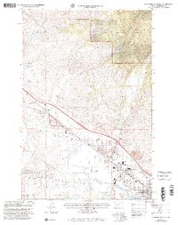
1999 Map of Northwest Missoula
USGS Topo · Published 2003About this map
Industrial and residential developments meet the foothills of the Lolo National Forest in this late-twentieth-century study of the northwest corner of Missoula. The landscape is defined by the convergence of major transit corridors and water management, where the Clark Fork flows past the West Side Park and an intricate network of irrigation channels including the Flynn Ditch and Grass Valley French Ditch. The presence of the Missoula Fire Technology Center Smokejumper Visitor Center near Johnson Bell Field highlights the region's importance as a hub for aerial firefighting and aviation operations.
Find a feature on this map
34 named features on this map. Tap any name to fly to it.
Don’t see what you’re looking for? This feature index may not catch every label — zoom into the map to look around manually.
Map Details
Editions of this 1999 Northwest Missoula Map
This is the sole edition of this map. No revisions or reprints were ever made.
Other maps of this area

1903 · Bonner
USGS Topo · 1:125,000

1912 · Missoula
USGS Topo · 1:125,000

1921 · Elbow Lake
USGS Topo · 1:125,000

1947 · Butte
USGS Topo · 1:250,000

1955 · Choteau
USGS Topo · 1:250,000

1956 · Wallace
USGS Topo · 1:250,000

1956 · Hamilton
USGS Topo · 1:250,000

1957 · Choteau
USGS Topo · 1:250,000

1958 · Butte
USGS Topo · 1:250,000

1958 · Choteau
USGS Topo · 1:250,000