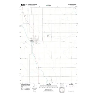
2010 Map of Northwood
USGS Topo · Published 2010About this map
The city of Northwood serves as the focal point of this northern Iowa landscape, positioned at the crossing of major thoroughfares and the Shell Rock River. This survey illustrates the town's layout including the Northwood Post Office and the Northwood Municipal Airport to the east. The surrounding area is defined by its rectilinear grid of rural roads, including State Line Rd marking the Minnesota border, and the natural expanses of Turkeyfoot Prairie in the south. Genealogists will find several burial sites recorded across the quadrangle, such as Stateline Cemetery near the northern boundary and South Shell Rock Cemetery south of the main settlement. The Shell Rock River and its tributary Deer Creek carve subtle paths through the agricultural sections, providing a contrast to the geometric precision of the county's road network.
Find a feature on this map
34 named features on this map. Tap any name to fly to it.
Don’t see what you’re looking for? This feature index may not catch every label — zoom into the map to look around manually.
Map Details
Editions of this 2010 Northwood Map
This is the sole edition of this map. No revisions or reprints were ever made.
Other maps of this area

1954 · Albert Lea
USGS Topo · 1:62,500

1954 · Hayward
USGS Topo · 1:62,500

1954 · Mason City
USGS Topo · 1:250,000

1957 · Mason City
USGS Topo · 1:250,000

1958 · Mason City
USGS Topo · 1:250,000

1972 · Manly
USGS Topo · 1:24,000

1972 · Northwood
USGS Topo · 1:24,000

1972 · Fertile NE
USGS Topo · 1:24,000
1972 · Fertile SE
USGS Topo · 1:24,000
1972 · Grafton
USGS Topo · 1:24,000