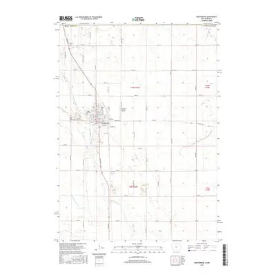
2015 Map of Northwood
USGS Topo · Published 2015About this map
Northwood serves as the central hub of this northern Worth County landscape, situated along the winding banks of the Shell Rock River. The area's settlement patterns are deeply tied to the land, evidenced by a series of family and community burial grounds including the Seater Family Plot, Sunset Rest Cem, and the South Shell Rock Cem situated south of the main town site. Along the northern boundary, the Stateline Cem sits directly on the border between Iowa and Minnesota, marking a unique point of local history where community geography transcends state lines. The surrounding countryside is defined by an extensive network of drainage infrastructure, such as Ditch Number 40 and Ditch Number 11, which reflect the region's agricultural adaptation. The Northwood Municipal Airport provides a modern landmark amidst a grid of rural roads named for birds and trees, from Mockingbird Ave to Spruce Ave.
Find a feature on this map
64 named features on this map. Tap any name to fly to it.
Don’t see what you’re looking for? This feature index may not catch every label — zoom into the map to look around manually.
Map Details
Editions of this 2015 Northwood Map
This is the sole edition of this map. No revisions or reprints were ever made.
Other maps of this area

1954 · Albert Lea
USGS Topo · 1:62,500

1954 · Hayward
USGS Topo · 1:62,500

1954 · Mason City
USGS Topo · 1:250,000

1957 · Mason City
USGS Topo · 1:250,000

1958 · Mason City
USGS Topo · 1:250,000

1972 · Manly
USGS Topo · 1:24,000

1972 · Northwood
USGS Topo · 1:24,000

1972 · Fertile NE
USGS Topo · 1:24,000
1972 · Fertile SE
USGS Topo · 1:24,000
1972 · Grafton
USGS Topo · 1:24,000