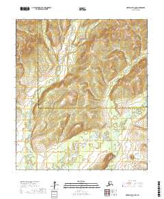
2017 Map of Norton Bay A-2 SW
USGS Topo · Published 2017About this map
North Fork Unalakleet River meanders southward through this interior Alaskan wilderness, eventually joining the primary Unalakleet River in the southern portion of the quadrangle. The terrain is defined by significant elevation changes, culminating at Old Woman Mtn in the southeast corner. This peak serves as a prominent landmark near the confluence where the Old Woman River feeds into the main river system. The landscape is bisected by the administrative boundary between the Nome Census Area and the Yukon-Koyukuk Census Area, a line that cuts across the river valleys. Mapping this remote region reveals the intricate drainages and high ridges that have long dictated movement through the Unalakleet River basin, serving as a critical corridor for travel between the coast and the interior.
Find a feature on this map
10 named features on this map. Tap any name to fly to it.
Don’t see what you’re looking for? This feature index may not catch every label — zoom into the map to look around manually.
Map Details
Editions of this 2017 Norton Bay A-2 SW Map
This is the sole edition of this map. No revisions or reprints were ever made.
Other maps of this area

1948 · Norton Bay
USGS Topo · 1:250,000

1950 · Unalakleet D-3
USGS Topo · 1:63,360

1950 · Norton Bay A-3
USGS Topo · 1:63,360

1951 · Unalakleet
USGS Topo · 1:250,000

1951 · Norton Bay
USGS Topo · 1:250,000

1952 · Unalakleet D-2
USGS Topo · 1:63,360

1952 · Unalakleet
USGS Topo · 1:250,000
1953 · Norton Bay A-2
USGS Topo · 1:63,360

1955 · Norton Bay
USGS Topo · 1:250,000

1964 · Unalakleet
USGS Topo · 1:250,000