
1950 Map of Norton Bay A-3
USGS Topo · Published 1958About this map
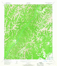
The North River dominates this 1950 landscape as it meanders through a territory defined by deep drainage patterns and complex elevation. Mapped by the Army Map Service using aerial photogrammetry, the sheet illustrates the winding course of the main waterway and its significant tributaries, such as Eggvik Creek. Human presence is minimal in this wilderness, represented only by a solitary Cabin in the northern reaches, emphasizing the area's isolation at mid-century. A prominent landmark is the North River VABM 1871 triangulation station, which served as a critical control point for the Corps of Engineers and the Geological Survey during their efforts to document the Alaska-Second Judicial Division. The lack of roads or established trails highlights a landscape where movement was dictated by the river valleys and the ridges between them.
Find a feature on this map
4 named features on this map. Tap any name to fly to it.
Don’t see what you’re looking for? This feature index may not catch every label — zoom into the map to look around manually.
Map Details
Editions of this 1950 Norton Bay A-3 Map
2 editions found
Other maps of this area

1948 · Norton Bay
USGS Topo · 1:250,000

1950 · Norton Bay B-4
USGS Topo · 1:63,360

1950 · Norton Bay B-3
USGS Topo · 1:63,360

1950 · Unalakleet D-3
USGS Topo · 1:63,360

1950 · Norton Bay A-4
USGS Topo · 1:63,360

1950 · Unalakleet D-4
USGS Topo · 1:63,360

1951 · Unalakleet
USGS Topo · 1:250,000

1951 · Norton Bay
USGS Topo · 1:250,000

1952 · Unalakleet D-2
USGS Topo · 1:63,360

1952 · Unalakleet
USGS Topo · 1:250,000