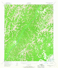
1950 Map of Norton Bay A-3
USGS Topo · Published 1967About this map
North River dominates this mid-century topographical survey, snaking through the center of a landscape defined by sharp elevation changes and unnamed drainage systems. The survey, based on 1950 aerial photography, reveals a wilderness largely devoid of permanent development, save for a single Cabin located in the northwestern reaches near a minor tributary. This lone structure serves as a primary indicator of human activity in an area otherwise characterized by its isolation. Towards the southern boundary, the map identifies North River VABM 1871, a vertical angle bench mark providing a precise elevation point for the Army Map Service’s cartography. The inclusion of Egavik near the western edge hints at the connectivity between the river systems and the coastal influences of the region, despite the absence of established roads or trails on this specific sheet.
Find a feature on this map
4 named features on this map. Tap any name to fly to it.
Don’t see what you’re looking for? This feature index may not catch every label — zoom into the map to look around manually.
Map Details
Editions of this 1950 Norton Bay A-3 Map
2 editions found
Other maps of this area

1948 · Norton Bay
USGS Topo · 1:250,000

1950 · Norton Bay B-4
USGS Topo · 1:63,360

1950 · Norton Bay B-3
USGS Topo · 1:63,360

1950 · Unalakleet D-3
USGS Topo · 1:63,360

1950 · Norton Bay A-4
USGS Topo · 1:63,360

1950 · Norton Bay A-3
USGS Topo · 1:63,360

1950 · Unalakleet D-4
USGS Topo · 1:63,360

1951 · Unalakleet
USGS Topo · 1:250,000

1951 · Norton Bay
USGS Topo · 1:250,000

1952 · Unalakleet D-2
USGS Topo · 1:63,360