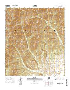
2015 Map of Norton Bay A-3 SE
USGS Topo · Published 2015About this map
Elevation contours and township boundaries define this coastal Alaska landscape within the Nome Census Area, as documented by the U.S. Geological Survey and the Bureau of Land Management. The terrain is structured by the Public Land Survey System, specifically marking the meeting of t16s r8w, t16s r7w, t17s r8w, and t17s r7w. This 2015 study presents a purely topographic view of the region, focusing on the steep relief and drainage patterns of the interior before they reach the Norton Bay coastline. Unlike maps of more developed regions, this sheet is characterized by its lack of named settlements or infrastructure, providing a clear record of the undisturbed physical geography and legal land divisions during the early 21st century.
Find a feature on this map
4 named features on this map. Tap any name to fly to it.
Don’t see what you’re looking for? This feature index may not catch every label — zoom into the map to look around manually.
Map Details
Editions of this 2015 Norton Bay A-3 SE Map
This is the sole edition of this map. No revisions or reprints were ever made.
Other maps of this area

1948 · Norton Bay
USGS Topo · 1:250,000

1950 · Unalakleet D-3
USGS Topo · 1:63,360

1950 · Norton Bay A-3
USGS Topo · 1:63,360

1951 · Unalakleet
USGS Topo · 1:250,000

1951 · Norton Bay
USGS Topo · 1:250,000

1952 · Unalakleet D-2
USGS Topo · 1:63,360

1952 · Unalakleet
USGS Topo · 1:250,000
1953 · Norton Bay A-2
USGS Topo · 1:63,360

1955 · Norton Bay
USGS Topo · 1:250,000

1964 · Unalakleet
USGS Topo · 1:250,000