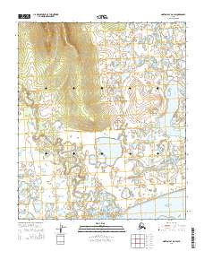
2014 Map of Norton Bay D-6 SW
USGS Topo · Published 2014About this map
Bering Sea waters meet the rugged shoreline of the Norton Sound in this coastal Alaskan study. The terrain is defined by the braided path of the Tubutulik River, which flows through low-lying wetlands into the Kwiniuk Inlet. To the east, the Kwik River carves its own course toward the sea, while smaller tributaries like Horseshoe Cr drain the higher elevations. This landscape reflects the complex hydrology of the Seward Peninsula, where shifting channels and numerous small ponds create a mosaic of aquatic environments. The map provides a precise layout of the Public Land Survey System grid, dividing the territory into Townships 7 and 8 South, Range 15 and 16 West. These coordinates are essential for researchers tracking land ownership and regional boundary shifts in this remote maritime region.
Find a feature on this map
9 named features on this map. Tap any name to fly to it.
Don’t see what you’re looking for? This feature index may not catch every label — zoom into the map to look around manually.
Map Details
Editions of this 2014 Norton Bay D-6 SW Map
This is the sole edition of this map. No revisions or reprints were ever made.
Other maps of this area

1948 · Norton Bay
USGS Topo · 1:250,000

1950 · Norton Bay D-6
USGS Topo · 1:63,360

1950 · Solomon C-1
USGS Topo · 1:63,360

1950 · Norton Bay C-6
USGS Topo · 1:63,360

1950 · Solomon D-1
USGS Topo · 1:63,360

1950 · Solomon
USGS Topo · 1:250,000

1951 · Solomon
USGS Topo · 1:250,000

1951 · Norton Bay
USGS Topo · 1:250,000

1955 · Norton Bay
USGS Topo · 1:250,000
2014 · Solomon D-1 NE
USGS Topo · 1:25,000