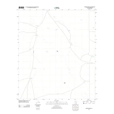
2012 Map of Norton Mesa
USGS Topo · Published 2012About this map
Fredrick Ranch and Love Ranch anchor this arid Hudspeth County landscape, illustrating the enduring presence of cattle ranching in the Trans-Pecos region during the early 21st century. The terrain is defined by the broad elevations of Norton Mesa and Roberts Mesa, where the management of water is paramount. A sophisticated network of catchment basins, including White Bull Tank, Twentyone Tank, and Andy Grant Tank, are distributed across the land to support livestock in an environment where natural surface water is scarce. Access to these remote holdings is maintained through unpaved routes such as Frederick Rd and Big Tank Rd, which connect the isolated ranch houses to the wider cattle-ranching infrastructure of West Texas.
Find a feature on this map
20 named features on this map. Tap any name to fly to it.
Don’t see what you’re looking for? This feature index may not catch every label — zoom into the map to look around manually.
Map Details
Editions of this 2012 Norton Mesa Map
This is the sole edition of this map. No revisions or reprints were ever made.
Other maps of this area

1895 · Sierra Blanca
USGS Topo · 1:125,000

1948 · Triple Hill
USGS Topo · 1:62,500

1951 · Red Hills
USGS Topo · 1:62,500

1954 · Van Horn
USGS Topo · 1:250,000

1955 · Black Mountains
USGS Topo · 1:62,500

1958 · Van Horn
USGS Topo · 1:250,000

1973 · Norton Mesa
USGS Topo · 1:24,000

1973 · Sneed Mountain NE
USGS Topo · 1:24,000
1973 · Sneed Mountain
USGS Topo · 1:24,000
1973 · Movie Mountain
USGS Topo · 1:24,000