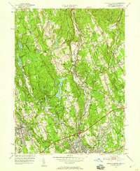
1951 Map of Norwalk North
USGS Topo · Published 1958About this map
Winnipauk and the northern reaches of Norwalk anchor the southern portion of this mid-century survey, showcasing a landscape transitioning from rural woodlands to suburban residential centers. The Merritt Parkway cuts across the lower third of the map, signaling the era's increasing connectivity between Fairfield County and New York. Local institutions like Wilton Jr High Sch and St Matthews Ch are nestled among numerous family-named peaks such as Comstock Hill and Belden Hill.
Find a feature on this map
71 named features on this map. Tap any name to fly to it.
Don’t see what you’re looking for? This feature index may not catch every label — zoom into the map to look around manually.
Map Details
Editions of this 1951 Norwalk North Map
4 editions found
Other maps of this area

1892 · Stamford
USGS Topo · 1:62,500

1892 · Danbury
USGS Topo · 1:62,500

1892 · Norwalk
USGS Topo · 1:62,500

1892 · Carmel
USGS Topo · 1:62,500

1893 · Carmel
USGS Topo · 1:62,500

1893 · Stamford
USGS Topo · 1:62,500

1893 · Norwalk
USGS Topo · 1:62,500

1894 · Carmel
USGS Topo · 1:62,500

1899 · Stamford
USGS Topo · 1:62,500

1915 · Danbury
USGS Topo · 1:62,500