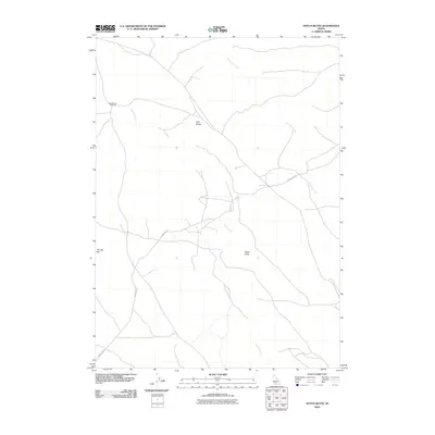
2010 Map of Notch Butte
USGS Topo · Published 2010About this map
Notch Butte and the surrounding high desert of Owyhee County are defined by a network of drainage ways and isolated volcanic markers. This high plateau is dissected by Sailor Creek and Deadman Creek, which carve paths through the arid landscape. The map highlights key navigation points for travelers in this open country, such as the distinct elevation of The Big Hill and the prominent Twin Buttes. Transport is largely restricted to established routes like Crows Nest Rd, which weaves between the drainages. A notable point of human activity or transit is Deadhorse Crossing, where a trail meets a creek bed in an area otherwise characterized by its remote and undeveloped nature. The presence of these specific named crossings and peaks suggests a landscape where water and high ground were essential for orienting movement across the sagebrush-covered plains.
Find a feature on this map
7 named features on this map. Tap any name to fly to it.
Don’t see what you’re looking for? This feature index may not catch every label — zoom into the map to look around manually.
Map Details
Editions of this 2010 Notch Butte Map
This is the sole edition of this map. No revisions or reprints were ever made.
Other maps of this area

1948 · Twentymile Butte
USGS Topo · 1:24,000

1948 · Glenns Ferry
USGS Topo · 1:62,500

1948 · Grindstone Butte
USGS Topo · 1:24,000
1949 · Grindstone Butte
USGS Topo · 1:24,000

1949 · Pasadena Valley
USGS Topo · 1:62,500

1949 · Indian Butte
USGS Topo · 1:24,000
1950 · Indian Butte
USGS Topo · 1:24,000
1951 · Glenns Ferry
USGS Topo · 1:62,500

1955 · Twin Falls
USGS Topo · 1:250,000

1956 · Blue Butte
USGS Topo · 1:62,500