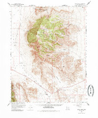
1960 Map of Notch Peak
USGS Topo · Published 1985About this map
The House Range dominates this mid-century landscape in Millard County, characterized by a complex network of canyons and high ridges. Significant elevation changes are marked by Notch Peak and Sawtooth Mountain, while the lowlands of Tule Valley and Little Valley flank the central massif. The map documents sparse but essential water sources in this arid environment, including Painter Spring and Watsons Cow Pond, which likely supported local ranching or prospecting efforts. Mining activity is evident through the Klondike Mine, Brown Queen Mine, and various Placer Mines located near the Amasa Valley. The distribution of these sites along Miller Canyon and Marjum Canyon suggests a period of exploratory resource extraction focused on the steep drainages of the range. Trails and passes like Sneakover Pass and Skull Rock Pass provide the primary means of navigating through the high country, connecting the more accessible basins to points like Hell'n Maria Kitchen.
Find a feature on this map
39 named features on this map. Tap any name to fly to it.
Don’t see what you’re looking for? This feature index may not catch every label — zoom into the map to look around manually.
Map Details
Editions of this 1960 Notch Peak Map
2 editions found
Other maps of this area

1908 · Fish Springs
USGS Topo · 1:250,000

1910 · Fish Springs
USGS Topo · 1:250,000

1953 · Richfield
USGS Topo · 1:250,000

1953 · Delta
USGS Topo · 1:250,000

1958 · Richfield
USGS Topo · 1:250,000

1958 · Delta
USGS Topo · 1:250,000

1959 · Cowboy Pass
USGS Topo · 1:62,500

1960 · Notch Peak
USGS Topo · 1:62,500

1960 · Crystal Peak
USGS Topo · 1:62,500

1960 · Conger Mountain
USGS Topo · 1:62,500