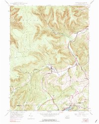
1946 Map of Noxen
USGS Topo · Published 1976About this map
Bowman Creek carves a deep valley through the high ridges of the Endless Mountains, serving as the primary corridor for settlement and transit between Forkston Mountain and Schooley Mountain. The 1946 topography reveals a landscape shaped by both natural drainage and industrial history, notably an Old Railroad Grade that parallels the creek. This route historically connected the timber and tanning hub of Noxen to the surrounding rail network. Further south, the terrain softens toward the popular recreational waters of Harveys Lake, where the community of Ruggles sits at the northern shore. Small rural clusters like Stull and Hettesheimer Corners are scattered along the narrow valley floors, while specialized sites such as the Childrens Welfare Center suggest the area’s role in providing social services and respite during the mid-twentieth century.
Find a feature on this map
34 named features on this map. Tap any name to fly to it.
Don’t see what you’re looking for? This feature index may not catch every label — zoom into the map to look around manually.
Map Details
Editions of this 1946 Noxen Map
5 editions found

Other maps of this area

1891 · Harveys Lake
USGS Topo · 1:62,500

1893 · Harvey Lake
USGS Topo · 1:62,500

1893 · Pittston
USGS Topo · 1:62,500

1943 · Scranton
USGS Topo · 1:125,000

1945 · Meshoppen
USGS Topo · 1:62,500

1945 · Jenningsville
USGS Topo · 1:24,000

1945 · Meshoppen
USGS Topo · 1:24,000

1946 · Tunkhannock
USGS Topo · 1:62,500

1946 · Kingston
USGS Topo · 1:24,000

1946 · Dutch Mtn
USGS Topo · 1:24,000