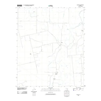
2010 Map of Nugent
USGS Topo · Published 2010About this map
Fort Phantom Hill stands as the primary landmark in this section of Jones County, anchoring a landscape where the Clear Fork Brazos River carves through the terrain. The area is characterized by a mix of historic settlement and petroleum extraction, with the Doty Oil Field and Lewis Steffens Oil Field indicating the region's industrial footprint. Near the river, the small community of Nugent serves as a local hub, while the Fort Phantom Hill Cemetery provides a critical point of interest for those researching local lineage. The drainage network, including Elm Creek and Flatrock Creek, defines the agricultural and ranching potential of the land, as seen at the Alexander Ranch near the river's bend. A web of county roads, such as W Lake Rd and Co Rd 319, connects these dispersed sites, reflecting a rural infrastructure built around the river and the oil fields.
Find a feature on this map
29 named features on this map. Tap any name to fly to it.
Don’t see what you’re looking for? This feature index may not catch every label — zoom into the map to look around manually.
Map Details
Editions of this 2010 Nugent Map
This is the sole edition of this map. No revisions or reprints were ever made.
Other maps of this area

1891 · Anson
USGS Topo · 1:125,000

1893 · Anson
USGS Topo · 1:125,000

1954 · Abilene
USGS Topo · 1:250,000

1957 · Hawley
USGS Topo · 1:62,500

1957 · Nugent
USGS Topo · 1:62,500
1957 · Hawley
USGS Topo · 1:24,000
1957 · Hamby
USGS Topo · 1:24,000

1958 · Abilene
USGS Topo · 1:250,000

1965 · Lueders West
USGS Topo · 1:24,000

1965 · Lueders East
USGS Topo · 1:24,000