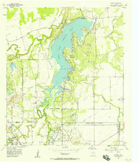
1957 Map of Hamby
USGS Topo · Published 1958About this map
Lake Fort Phantom Hill dominates this mid-century landscape northeast of Abilene, where water management and industrial infrastructure shape the West Texas terrain. This 1957 survey captures the reservoir at its normal pool elevation of 1626 feet, supported by a complex network of an aqueduct, a ditch, and a Pumping Sta. The meeting of Jones and Taylor counties is marked by a mix of agricultural land and early suburban development, evidenced by the Drive-in Theater and Radio Tower near the southwestern corner.
Find a feature on this map
32 named features on this map. Tap any name to fly to it.
Don’t see what you’re looking for? This feature index may not catch every label — zoom into the map to look around manually.
Map Details
Editions of this 1957 Hamby Map
4 editions found
Other maps of this area

1890 · Abilene
USGS Topo · 1:125,000

1891 · Anson
USGS Topo · 1:125,000

1892 · Abilene
USGS Topo · 1:125,000

1893 · Anson
USGS Topo · 1:125,000

1954 · Abilene
USGS Topo · 1:250,000

1957 · Hawley
USGS Topo · 1:62,500

1957 · Kirby Lake
USGS Topo · 1:62,500

1957 · Abilene West
USGS Topo · 1:24,000

1957 · Abilene East
USGS Topo · 1:24,000

1957 · Nugent
USGS Topo · 1:62,500