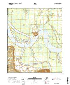
2017 Map of Nulato D-3 SW
USGS Topo · Published 2017About this map
The Yukon River dominates this interior Alaska landscape, creating a dynamic environment of braided channels and shifting landforms such as Bishop Rock Island. Along the northern banks, the settlements of Whontleya and Yistletaw sit near the water's edge, highlighting the river's historical importance as a primary transportation corridor through the wilderness. The terrain is marked by significant landmarks including Bishop Rock and Cone Point, which served as vital navigational aids for river travelers.
Find a feature on this map
13 named features on this map. Tap any name to fly to it.
Don’t see what you’re looking for? This feature index may not catch every label — zoom into the map to look around manually.
Map Details
Editions of this 2017 Nulato D-3 SW Map
This is the sole edition of this map. No revisions or reprints were ever made.
Other maps of this area

1945 · Nulato
USGS Topo · 1:250,000

1951 · Nulato
USGS Topo · 1:250,000

1952 · Nulato D-3
USGS Topo · 1:63,360

1952 · Nulato C-3
USGS Topo · 1:63,360

1952 · Nulato C-4
USGS Topo · 1:63,360

1952 · Nulato D-4
USGS Topo · 1:63,360

1952 · Nulato
USGS Topo · 1:250,000
1953 · Nulato C-4
USGS Topo · 1:63,360
1954 · Nulato D-3
USGS Topo · 1:63,360

1964 · Nulato
USGS Topo · 1:250,000