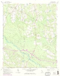
1970 Map of Nunez
USGS Topo · Published 1986About this map
The Ohoopee River and Yam Grandy Creek define the low-lying drainage patterns of Emanuel County in this 1970s survey, revised to include mid-1980s developments. The settlement at Nunez sits at the junction of the Central Of Georgia rail line and an Old Railroad Grade, reflecting a landscape shaped by timber and transit. Small rural communities like Wesley, Lexsy, and Lombard are scattered across the terrain, each anchored by local landmarks such as the Lexsy Sch or the New Hope Ch. Genealogists will find a dense concentration of family burial grounds throughout the quadrangle, including the Youmans Cem, Yeomans Cem, and Phillips Cem. In the southern reaches, the Oak Park Lookout Tower stands near the river, while several pits indicate localized mining or excavation activity in the sandy soils of the region.
Find a feature on this map
21 named features on this map. Tap any name to fly to it.
Don’t see what you’re looking for? This feature index may not catch every label — zoom into the map to look around manually.
Map Details
Editions of this 1970 Nunez Map
3 editions found
Other maps of this area

1957 · Macon
USGS Topo · 1:250,000

1958 · Macon
USGS Topo · 1:250,000

1964 · Macon
USGS Topo · 1:250,000

1970 · Cobbtown
USGS Topo · 1:24,000

1970 · Oak Park SW
USGS Topo · 1:24,000

1970 · Covena
USGS Topo · 1:24,000

1970 · Nunez
USGS Topo · 1:24,000

1970 · Oak Park
USGS Topo · 1:24,000

1971 · Norristown
USGS Topo · 1:24,000

1971 · Stillmore
USGS Topo · 1:24,000